Resources and data available for use, with appropriate acknowledgement. Please let Director Gregory Gilbert (ggilbert@ucsc.edu) know if you download data, and what you plan to do with it.
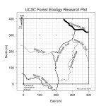 |
Trail map of the 16-ha UCSC Forest Ecology Research Plot (.png) v. June 2015 |
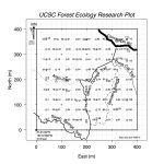 |
Trail map that shows the locations of all the litter trap and herp boards on the ferp. Feb 2017 |
| Data from first three censuses |
The full set of data from the three censuses is available on Dryad as a .csv flat file (https:// doi.org/10.5061/dryad.6q573n64s). Additionally, the data are available on the ForestGEO web site at https://forestgeo.si.edu/explore-data/uc-santa-cruz-termsconditionsrequest-forms. |
| FERP2007data.csv2007 | Census data, original 6-ha plot (0-200m E and 0-300m N. (comma delimited .csv) All woody stems (dbh≥1cm), including 8,130 individuals and 31 species. Columns are: tag, species code, date of tagging, dbh in mm, m east in plot, m north in plot, number of stems, status, basal area (including multiple stems), distance to closest 20-m post, nearest 20-m post east, nearest 20-m post north, UTM East, UTM North. Data are also curated by the Center for Tropical Forest Science on the CTFS server. |